Aran Fawddwy

I sit here, watching dawn over the city. The busses are rolling and the runners bobbing along the bustling Burley Road, in the heart of Leeds. I’m plotting. Tomorrow I’ll be driving my partner down to the Herefordshire/Shropshire border for a wedding this weekend, to which, though my sincere congratulations are extended without hesitation to the happy couple, I am gratefully not attending. Instead of being in an uncomfortable room with scores of people I don’t know, I’ll be on the paths and marshes of one of Wales’ least pestered peaks. Aran Fawddwy. Most likely alone.

Planning, in earnest, starts today.

Weather looks to be a little damp, but quite mild; 8 degrees and light wind from the South East. I’ll be traveling there and back on the day, most likely, so of more concern is the daylight hours at my disposal, which is roughly 20 past 8 to half past 4. 8 hours, ish. Should give me plenty of time to do the circular route to the summit and return to the car park, but not if I spend half of them on the road getting there. the route card indicates 4 – 5 hours, but my legs are aging and unpracticed, so I’ll allow 6, which means if I’ve not set off by 10, I’ll be potentially night-nav’ing on and unfamiliar hill, which I’d rather avoid. So it’ll be an early start. No bad thing. I like the mornings.

Kit:
1. Waterproofs & gaters. cold is fine, wet is fine, but both together are deeply undesirable.
2. Warm layers, because cold is only fine if you can get warm, so best to avoid it if possible.
3. Navigation stuff – the paths up there are, by all accounts, at times ill-defined, so it’ll be involving some map & compass practice. Good. it’s been a while and I fancy polishing up on that old skill
4. Winter gear… I’m not 100% sure of the conditions on the top, but I know I don’t want to be looking for something I should have brought, but didn’t. An axe is at times handy anyway, and though I’ll most likely leave the crampons in the car, I’ll for sure have them with me just in case. I’ll make that decision on the morning when I can see the summit.
5. first aid & emergency kit, plus one of those emergency bothy shelters I keep meaning to gather but never do.
6. Options. having stuff to choose from in the car is NEVER a bad idea. better to be looking at it than for it, I always say.
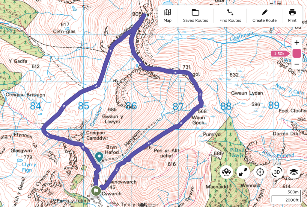

The Route


The Day Itself:

After driving down from Leeds to the Welsh border, we stayed with some old friends about an hour and 40 minute drive from the hill, so after a very leisurely set-off at just after 8, myself and a friend who’d decided to join me the night before, left the van in the car-park at almost exactly 10am. A short walk up the farm track to the new glamping pods dotting the valley, the clearly marked path for Aran Fawddwy led off to the left, and the hour of steepest ascent. The path is exceptionally good, well marked and maintained, and is not at all as difficult as some of the online trail reviews will have you believe (about a 60% on the Cadair Idris scale).

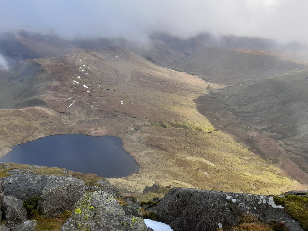
There were one or two moments when a hand was needed to move past a particularly larger rock or 3, so I suppose one could claim having scrambled part of it, but if making such claims, in needs to be stated that it’s very, very low in the grade. The way up, though, is stunning. The looming mass of Glasgwm to the south and opening expanse of Cwm Cywarch below are just sublime. By just after 11, we had made it to the more spaced-out contours and the all-but impossible to miss or loose, path to the summit. It can be a little damp underfoot, but is nothing that a modern walking boot can’t cope with ease, and a handy fence at hip height, all but all the way to the top.

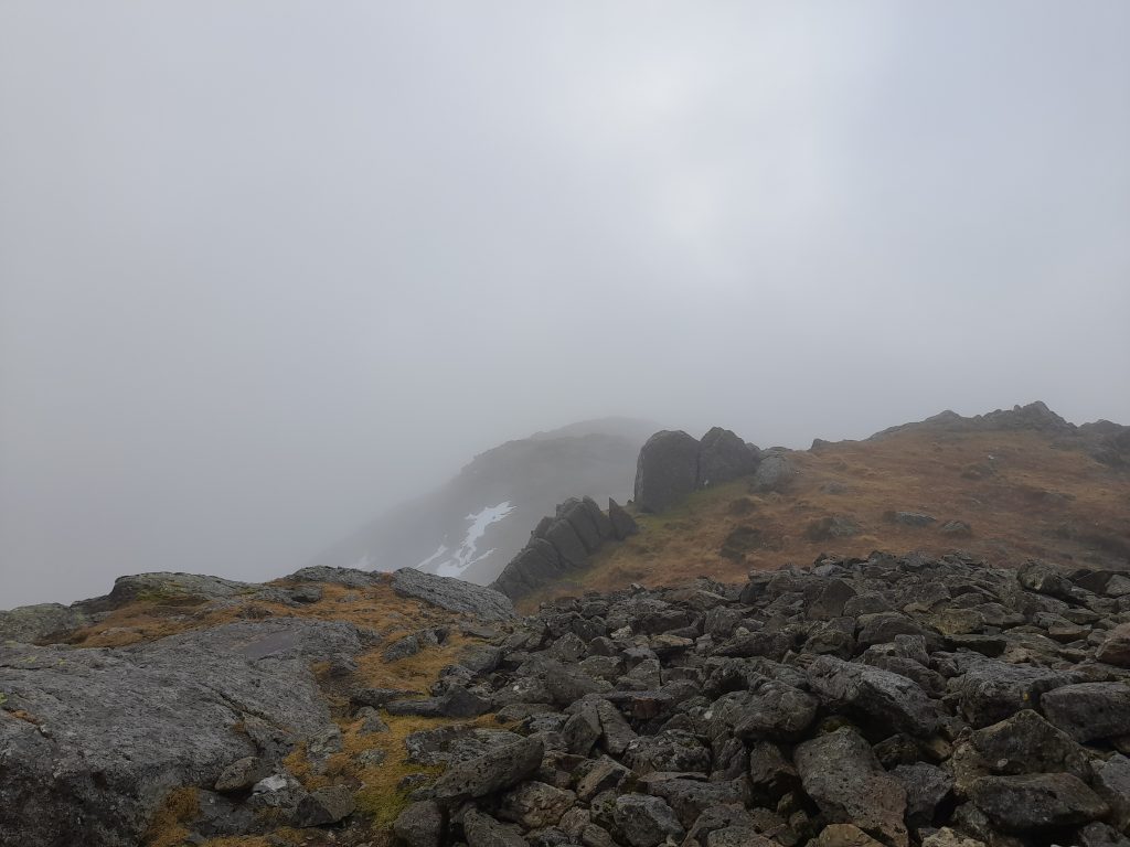
We attempted this in January, after some particularly extravagant snowfall a week or so before, so despite the unseasonably mild and pleasant weather (10mph winds and a very comfortable 5 degrees or so on the top), there was still some snow patches underfoot, which made for some appreciated visual entertainment, but nothing detrimental to easy navigation. If anything, I’d hoped for a bit more…

At half past 12, and having chosen to walk on a compass bearing for the last 400m, after the fence we’d followed for the last hour or so deviates to the north of the line to the summit, we reached the summit cairn in thick fog, with about 20-30m of visibility. Removing gloves and resting walking poles for the obligatory photographs, we were rewarded by the sudden clearing of the fog to reveal the utterly spectacular views from the top of the tallest mountain south of Snowdon.


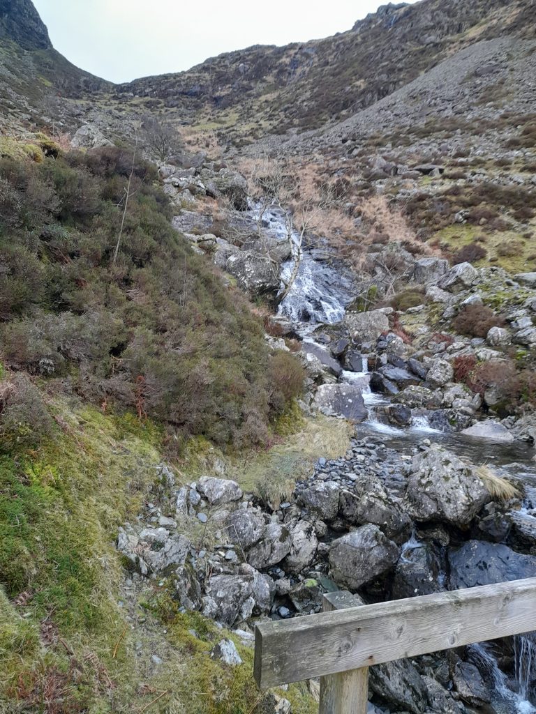
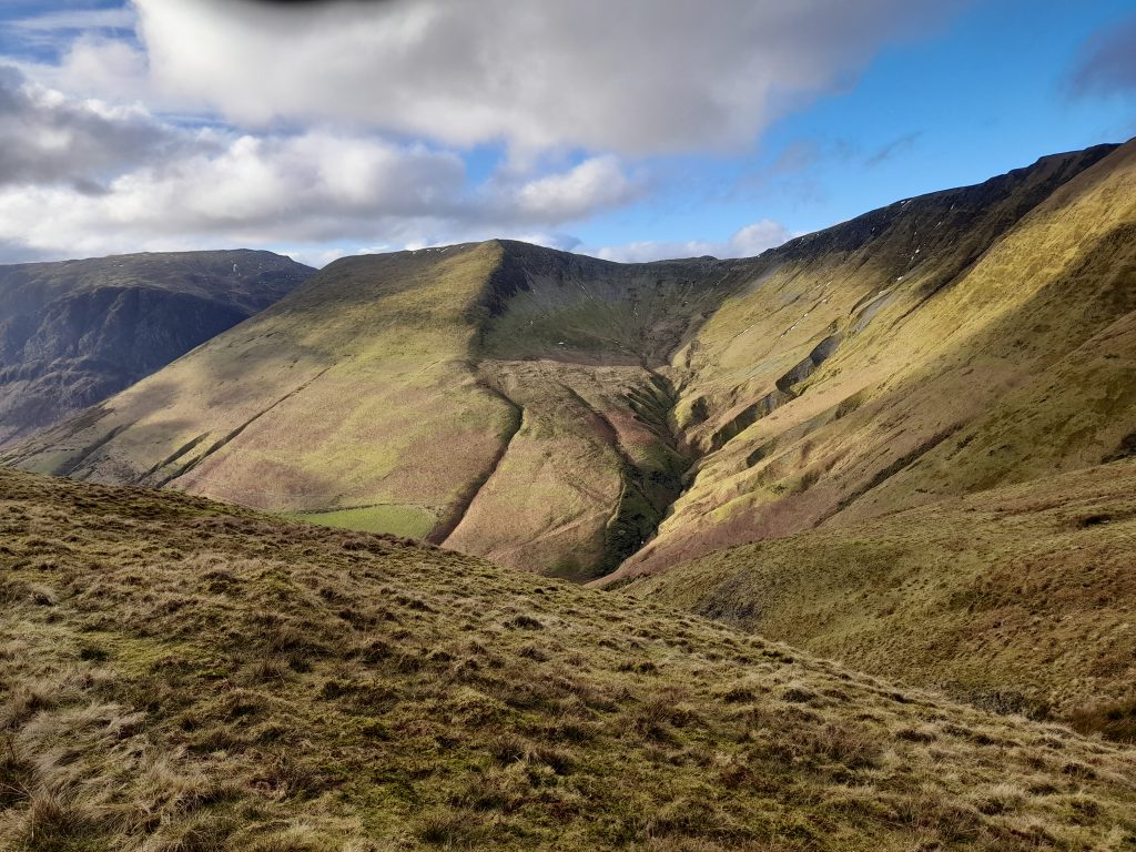
Taking another rough bearing and heading almost directly south, to pick up the path to Drysgol and Waun Goch, we started on the long, steady walk back to the carpark. The terrain on this half of the loop is much less technical, and could be accused of being dull, were it not for the amazing scenery of the Cwm and surrounding hills and Llyns, with a couple of particularly noteworthy exceptions; the thin bridge of Drws Bach, which is a very sedate affair when compared to more technical ‘ridges’, but nevertheless supplies some of that ‘airy’ feeling, in a very easily digestible form, and the fords a few thousand meters further along, down the long steady descent on the flank of Waun Goch, which again, are visually very appealing and give a feeling of real mountain walking, in a very manageable dose. This descent could be, again, accused of being a bit sedate, but doing the route this way round, is something of a reward, with the easy terrain and wonderful visual stimulus of Cym Cywarch.

I’d rate this as easy-to-moderate for a reasonably fit or experienced hillwalker, and in more gnarly conditions it would obviously be a little tastier, but if you need a stunning summit, with an entertaining ascent and easy-as-they-come access, this is it. I had a fantastic day, and was thoroughly pleased with the choice. I recommend it to you, too.

If I am ever looking for a Welsh route that’s a bit quieter (a lot quieter) than average, that’s beginner friendly and supplies just the right amount of ‘wow-factor’, this may well be the top of my list.

Cadair Idris, Feb 2013

Following on from our adventures in the Glyderau on Saturday, Sunday morning came and we made our way by convoy down to Cadair Idris, arriving at a thoroughly civilised 11 O’Clock ish. After a leisurely walk up through the very pleasant woodland and waterfalls up from Dol-y-cae, we emerged into the valley below Llyn Cau.

Forest Steps
The steps through Dol-y-cae
waterfall
She’s a waterfall

After the gentle ascent to Llyn Cau we stopped at the small boulder on the eastern shore for some breezy and slightly chilly sandwiches. The wind having picked up slightly and in a westerly direction, we were grateful to be on our way once again, skirting the northern side of the lake to pick up the Fox Path to the west.

Llyn Cau
Walking the northern shore of Llyn Cau


After negotiating the rocky north western shore of the lake, we picked up the path and made for the scrambley ascent to the ridge above Crag Cau, which is now firmly on our climbing ticklist on our return, whenever that turns out to be.

foxes path
A saw not a fox on the whole route, I also believe the word ‘path’ to be something of an exaggeration.

On reaching the ridge, the utterly sublime view was a terrific reward for what was a very brief, half hour slog up the hill.

The view from the ridge above the fox path, towards the south, over the gulf that contains Llyn Cau.
The view from the ridge above the fox path, towards Craig Lwyd in the south east, over the gulf that contains Llyn Cau.

We headed up to the summit, through the rock fields that litter the way up to it, to be rewarded once again buy the stunning views out across Llyn Gadair and on to Dolgellau, Barmouth and Fairbourn in the distance.

We took the Minffordd Path down from the summit, skirting the ridge around Llyn Cau to the west and south, picking up again the path that leads down to the forest from the eastern shore of the lake. This path, as well as being so well laid as to make the way no more a mountaineering feat than picking up bread from the shop, affords some awesome glimpses of the lake through the regular gullies along it’s northern side, catching the sun in the low south as we did, these made for some very nice pictures indeed, let down only by my abysmal abilities as a photographer.

Gully
one of the few gullies along the Minffordd path

All in all a grand and surprisingly easy day, excepting the Fox Path and some fairly enthusiastic wind on the ridge, ended by a fine mug of tea and the most substantial flapjack I have had in a long while, from the delightful tea room down by the car park.

Tryfan and Glyder Fach, Feb 2013

Over 3 months since the last outing, rum left safely at home and some extra legs at hand, myself and 5 others made the trek up the A5 to the wonderful bunkhouse at the foot of Tryfan. If you’ve never stayed at the Gwern Gof Uchaf campsite/bunkhouse then I would heartily recommend it, there is nothing quite so appreciated after a hard day in the hills as a comfortable bed and a kitchen in which someone else cooks.

We arrived, as is customary, in dribs and drabs on Friday evening, all having driven up from our various locations in England after work, myself and another being the first on the scene picked up the key, filled up the kettle and got dinner on. Some time later the gang all assembled, we formulated a plan for the following day, it looked something like this;

The plan was formed to ascend by means of the North Ridge, then move down from the summit to Bwlch-Tryfan then make an attempt on Glyder Fach via Bristly Ridge, to descend Y Gribin.

Objective No.1 – Tryfan.

2013-02-17 08.56.51

In the words of my Grandfather, an old mountaineer and climber of some experience “Tryfan is a serious mountain Clive, I took your Grandmother there to teach her to glissade”. From which I think he meant a warning to be careful and a vague admission of some ill-intent towards my long suffering Grandmother.

The following morning we got out early(ish) this time, we were out the door for 8 O’Clock and more than a good way up the hill for 9. The trip up Tryfan was one I shall always remember, the way was relatively easy on reflection, although reasonably exposed at times it was highly enjoyable, and has firmly placed a number of climbs on my wish list, Milestone Butress being near the top.

After the usual photographic shenanigans a-top the Cannon, we made our way to the North Peak, after descending the small saddle between the North Peak and Adam & Eve at the summit, we delayed at the head of North Gully to take yet more pictures perched atop the large stone bridge that marks the end of the climb. Upon readying ourselves to leave though, the day took a turn for the interesting when we heard a number of forlorn cries for assistance from below, which turned out to be an unfortunate chap, who, upon leaving his party to assist an unwell ascensionist back to the safety of level ground had decided to use North Gully as a shortcut and had some slippery experiences in the snow and a banged head for the trouble. Sensibly he then decided to stay put and shout for help. Luckily, no more than 40 meters away was a party of idiots buggering about on a scary rock (us), with harnesses on and ropes attached, because we aren’t that silly. At which point I descended the slope with an extra harness and rope and we belayed the unfortunate fellow to the top, where the rest of his, to this point oblivious, party had begun to congregate. All in all, the photographic buggering about and impromptu rescue effort took about an hour, in which time the sky had cleared and the summit of Tryfan beckoned in the clear, warm afternoon light.

After some cheese sandwiches and a small rest, we began the descent into Bwlch-Tryfan and our journey onwards, from the sunny gloriousness of Tryfan, to the ominous and cloudy Bristly Ridge.

Sunny Tryfan, looking back up to the summit from the south.
2013-02-16 12.37.40
Across the peak to Bwlch Tryfan and Glyder Fach

Sensible people would now turn around and go back. We however ploughed ahead sure and safe in our abilities to climb, route find and map read in heavy fog without compasses (thank you, magnetic Glyder Fach) and not die.

Objective No.2 – Glyder Fach

Encouraged by the worried looks of our fellow scramblers on Tryfan, we headed into the gloom, scrambling the snowy slopes of Bristly Ridge up to the more serious rock outcrops and crags. Over an hour of tentative route finding (essentially, choosing direction based on if it was ‘up’ or not), scrambling, climbing, swearing and quelling the ever increasing urges to panic, we made our way past a group of roped up, crampon wearing, ice-axe wielding, helmet wearing, proper mountaineers. With words of mutual encouragement and a look of what I am fairly certain was fear mixed with the concern you might see a person have for someone drunkenly starting a fight with a tiger, we climbed past them (after asking for directions of course), ropeless, axeless and spikeless, to the top ridge and along to the summit plateau of Glyder Fach.

Meeting some walkers who had elected for a slightly less mental route of ascent we decided to head over to the cantilever at the summit for some pictures, then head down. By this time we only had around 2 hours of daylight left so decided we should descend by the miners path, rather than Y Gribin, to get back before the onset of nightfall and yet more impromptu adventures.

Breaking the cloud into the view of the sunset shining onto the foothills of the Carneddau on the other side of the valley, lighting everything up as it did in a golden bath, is something I will always remember.

We trudged down the miners path back to the bunkhouse a happy bunch, some frustrating navigating at the summit behind us (we only walked in one circle after all, not loads) we reflected on the beauty of the land around us, how lucky we were to enjoy it without mishap, and looking forward to the Spaghetti we were going to cook as soon as we got back.

Rhinog Fawr, Nov 2012

So back in November 2012 myself and 2 friends headed over to Snowdonia to attempt the Rhinog traverse. We didn’t make it…

Arriving in Tal-y-bont to stay in a convenient caravan on friday night, we ate pizza and made our preparations for the following day. We were to be up for the first train to Talsarnau to make the ascent up from sea level through the Rhinog foothills up to Llyn Eiddew-Mawr and then on to the Roman Steps and after that, the Rhinogau themselves.

What actually happened was rather less bushy-tailed.

Missing the first train, which would have got us into Talsarnau around 08:40, we had a leisurely stroll on the beach, after waiting for the next train (10 O’Clock) we eventually got on our way up through Talsarnau and Soar at just before 11. Having made less than optimal use of the available daylight (which was due to disappear at around 5 in the afternoon) we made fairly leisurely progress up to the Llyn for lunch, passing through the beautiful woodland around Soar.

IMAG0953

Leaving the woodland behind and passing into the rolling grassland between the woodlands and the slightly less hospitable foothills around Clip, the pre-lunch mood of the team was bouyant and happy. The sun was out warming our backs and the temperature was at a balmy 7 degrees. All in all very comfortable and made for a wonderful morning.

IMAG0958
Continue reading “Rhinog Fawr, Nov 2012”